Catherine H. Popovici is the 2022-24 Austen-Stokes Ancient Americas Endowed Postdoctoral Fellow in the Department of the History of Art at Johns Hopkins University. She specializes in the visual culture of the ancient Americas, with a specific focus on the intersection of landscapes and sculpture in Mesoamerica. She has previously held fellowships at the Center for Advanced Study in the Visual Arts (CASVA), the John Carter Brown Library, and the Blanton Museum of Art. Popovici earned a PhD in Art History from the University of Texas at Austin, a M.A. in Art History from Penn State, and a B.A. in the History of Art from Smith College.
During the Aztec month and festival season of Huey Tozoztli, four local rulers departed the inner Basin of Mexico and began their annual pilgrimage to the top of Mount Tlaloc.1 Gathering at Tetzcoco, the tlahtoque—the Nahuatl term for rulers of city-states, here referring to the polities of Tenochtitlan, Tlacopan, Xochimilco, and Tetzcoco—departed to the east (Fig. 1). The trek undertaken by the allied sovereigns coincided with the height of the dry season. They ascended the treacherous mountain slope to petition for rain, part of a larger effort to initiate a renewal of nature for a successful upcoming agricultural season. This specific pilgrimage was enacted sometime in late April to early May, during the Late Postclassic period (1250 - 1519 CE), to fulfill a religious obligation and usher in a season of rebirth.2
- 1This essay was written during my time as the 2020-2022 Ittleson Fellow at the Center for Advanced Study in the Visual Arts. I thank the Center for their generous support. I also wish to thank Matthew H. Robb, Amara Solari, Kendyll Gross, Theresa A. Cunningham, and Donato Loia for their insightful feedback on earlier drafts of this project. I am indebted to Josefrayn Sánchez-Perry and Elliot Lopez-Finn for sharing their valuable insight on the religion of Postclassic Central Mexico. Elliot and Josefrayn workshopped several of these ideas with me and provided much feedback on earlier versions of this essay; I thank them for their generous comments, especially regarding the Nahuatl-language material. Megan McDonie and I have had many conversations about mountains over the years and I thank her for inspiring some of the ideas presented here and for directing my attention to a handful of the cited sources. Lastly, I warmly thank the article’s two anonymous reviewers as well as the Special Issue Editors for their thoughtful feedback. Any errors are my own.
- 2Richard F. Townsend, “The Renewal of Nature at the Temple of Tlaloc,” in The Ancient Americas: Art from Sacred Landscapes, ed. Richard F. Townsend (Chicago: The Art Institute, 1992), 173-174; Diego Durán, The Book of the Gods and the Rites of the Ancient Calendar, trans. and eds., Fernando Horcasitas and Doris Heyden (Norman: University of Oklahoma Press, 1971), 156-157. In this work, I take Townsend’s foundational understanding of “nature renewal” ceremonies and advance this interpretation, illuminating how the mountain slope was a crucial component of the pilgrimage and integral to this interpretation.
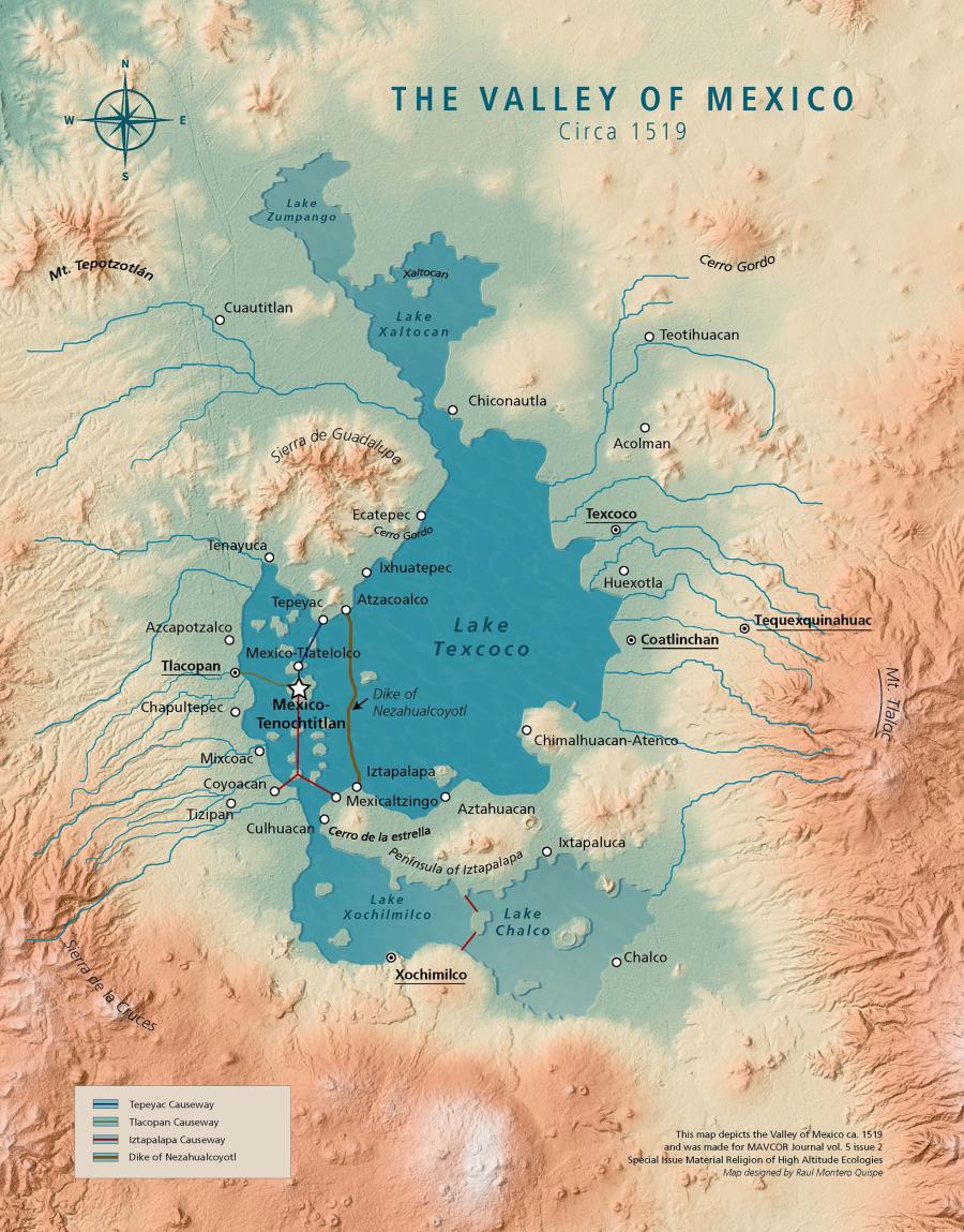
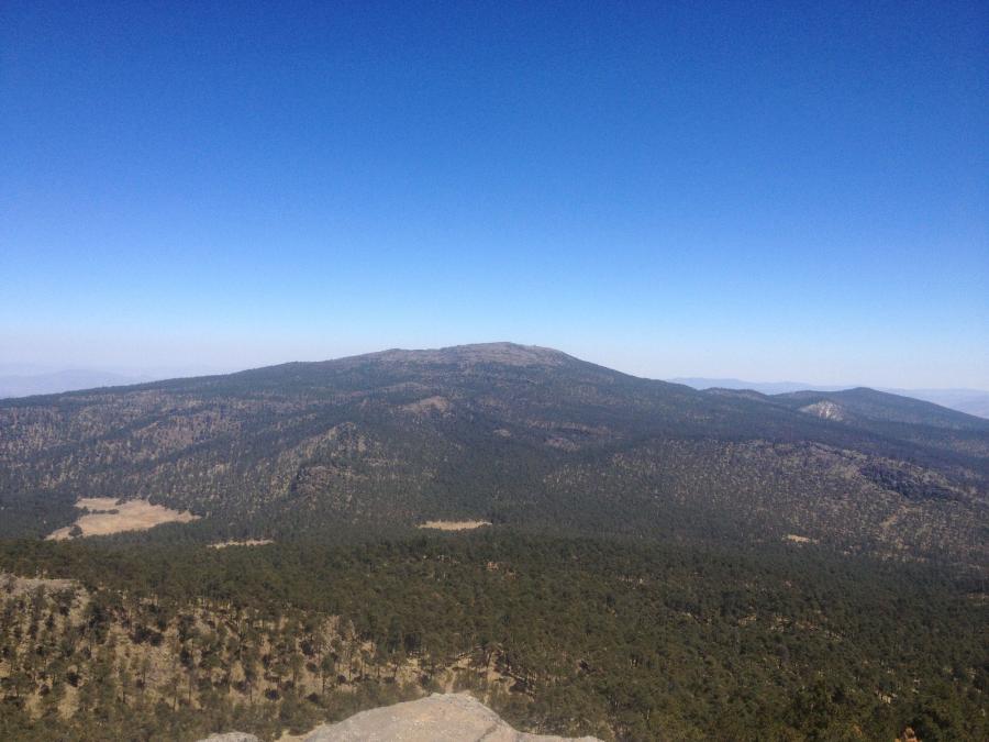
Fig. 3 Mount Tlaloc. Image in the public domain; photograph by Bodofzt; Wikicommons via a Creative Commons Attribution-Share Alike 4.0 International license. No changes made.
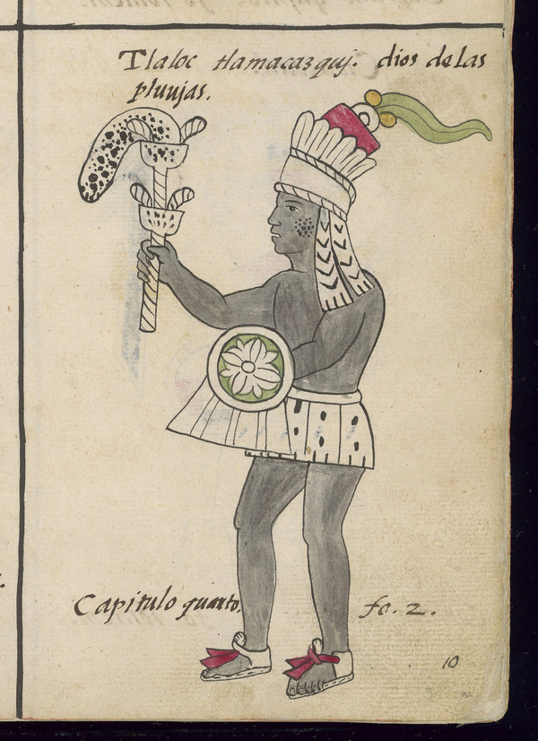
Fig. 2 Bernadino de Sahagún and Nahua artists/scribes, Florentine Codex (detail), 1575-1577 CE, wood-pulp paper and pigment. Florence, Biblioteca Medicea Laurenziana, Ms. Med. Palat. 218, l. 1, f. 10r. With the concession of MiCE. Further reproduction by any means is prohibited.
The ascent of the tlahtoque responded to and engaged with the topography of the Valley of Mexico. The undulating geography of the region shaped how ritual participants physically moved through the landscape during periods of devotion. The summit of Mount Tlaloc is the tallest peak of the Continental Divide, which distinguishes the Valley of Mexico from the adjacent Puebla-Tlaxcala Valley.1 With an altitude of over 13,000 feet above sea level, some 6,000 feet above the populous valley below, Mount Tlaloc served as the primary dwelling place for a principal deity of the same name in the Aztec pantheon.2 Located about twenty miles east of Tenochtitlan, the Aztec capital, Mount Tlaloc was part of a suite of sacred loci that protected and distinguished the valley. Presentations of various offerings and feasts, for example, encoded the peak with symbolic referents as the mountain served as a termination point for numerous pilgrimages. During calendrical events, ritual participants processed across the landscape to kinetically map cosmological cycles, and then climbed the mountain slope to foster communication with the divine.3
Home to the Sierra Nevada Volcanic Range—which includes the mountains of Popocatépetl, Iztaccíhuatl, Telapón, and Tlaloc—this environment is dominated by a subtropical highland climate, an unstable water table, and seismic activity.4 The Nahuas conceived the mutability of this landscape, which changes continuously throughout the day and with the seasons, as part of a longstanding view that the environment and strong meteorological conditions are numinous, imbued with or embodying the sacred. These weather patterns were tied to Tlaloc’s identity as the deity of rain who presided over life and sustenance and was capable of wielding lightning and launching massive storms (Fig. 2).5 Tlaloc materialized as rain-filled clouds, especially as cumulus forms that descended from the sky and rested atop mountain peaks. These clouds, gathering around high mountains, were part of the reason why Tlaloc was thought to dwell on Mount Tlaloc and the neighboring peaks.6 As the deity of sustenance, who controlled rain and hail, Tlaloc was responsible for the perennial agricultural cycles of trees, grass, and maize.7 While he was thought to inhabit all of the mountainous landforms that composed the Sierra Nevada range, Mount Tlaloc was his primary dwelling place.8 His mountain abode hosted weather patterns that were so distinct—partly because of its soaring altitude—that the deity communicated to the population below via clouds, rain, lightening, and storms.
While the Nahua of the Late Postclassic period were the last to venerate and worship at Mount Tlaloc before Spanish occupation, the mountain remained a prominent fixture of ritual activity well into the sixteenth century (Fig. 3).9 Inversely, objects dating to the Preclassic period (2000 BCE-300 CE) as well as to the city-state of Teotihuacan (100 BCE-500 CE) were unearthed during archaeological investigations conducted in the twentieth century, indicating that the mountain’s summit was a ritual location for numerous cultures across epochs.10 Many sixteenth-century chroniclers commented on the activities that culminated at the mountain’s summit, acknowledging that the meteorological conditions at the peak rendered it a sacred location for ritual activity. Dominican friar Diego Durán (ca. 1537-1588) in his documentation of Indigenous lifeways during early Spanish occupation of New Spain describes the meteorological phenomenon that occurred on Mount Tlaloc. Durán observed that “clouds become cold” and that “storms of thunder, lightning, thunderbolts, and hail” accumulated at the mountain’s peak.11 Sixteenth-century documentation and archaeological data describe a pilgrimage that culminates on Mount Tlaloc’s summit, but offer little detail about the ascent itself.
- 1The term “high-altitude” is subjective and composed of a wide range of variables. I follow Dean Jacobsen and Olivier Dangles’s position that high-altitude locales of 3,000 meters and higher represent the majority of ecological studies focused on high elevation. For Jacobsen and Dangles, high-altitude landforms, regardless of latitudinal considerations are “accompanied by certain characteristic environmental conditions (e.g. low oxygen availability and high ultraviolet (UV) radiation) that justify a special focus on altitude itself.” Dean Jacobsen and Olivier Dangles, Ecology of High-Altitude Water (Oxford: Oxford University Press, 2017), 2.
- 2The recorded altitude of Mount Tlaloc differs slightly based on publication. Charles Wicke and Fernando Horcasitas record the mountain’s altitude at 13,270 feet above sea level while Richard F. Townsend reports that the mountain’s altitude is 13,500 feet. Charles Wicke and Fernando Horcasitas, “Archaeological Investigations on Monte Tlaloc, Mexico,” Mesoamerican Notes 5 (1957): 83; Richard F. Townsend, “The Mt. Tlaloc Project,” in To Change Place: Aztec Ceremonial Landscapes, ed. by Davíd Carrasco (Niwot: University Press of Colorado, 1991), 26.
- 3Johanna Broda, “The Sacred Landscape of Aztec Calendar Festivals: Myth, Nature, and Society,” in To Change Place: Aztec Ceremonial Landscapes, ed. Davíd Carrasco (Niwot: University Press of Colorado, 1991), 74-120; George Kubler, “Pre-Columbian Pilgrimages in Mesoamerica,” Diogenes 32 (1984): 12-13.
- 4Luca Ferrari, Teresa Orozco-Esquivel, Vlad Manea, and Marina Manea, “The Dynamic History of the Trans-Mexican Volcanic Belt and the Mexico Subduction Zone,” Tectonophysics 522-523 (2012): 122-149.
- 5Broda, “The Sacred Landscape of Aztec Calendar Festivals,” 98, 101.
- 6Diego Durán, Historia de las Indias de Nueva España e Islas de la Tierra Firme, vol. 1, ed. Ángel Ma. Garibay K. (Mexico: Editorial Porrúa, 1967), 82.
- 7In depictions of Tlaloc that circulated during the Postclassic and early colonial periods, the deity was rendered with slightly different visages. At times, he was depicted with fanged teeth and goggle eyes characteristic of pre-contact Nahua iconography and in other renderings, his depiction was in line with colonial-era illustrations that circulated around New Spain, representing him in human form. Bernadino de Sahagún, Florentine Codex: General History of the Things of New Spain, translated by Arthur J. O. Anderson and Charles E. Dibble (Santa Fe: School of American Research, 1950-1963), Book 1, Chapter 4, 7.
- 8The Nahuatl term altepetl, which translates literally to “water-mountain” references city-states or groups of people. Often altepetl visually manifested as a mountain glyph, indicating that communities ideally settled near mountains, which were conceived of as containers of water and life-giving. Barbara E. Mundy, The Death of Aztec Tenochtitlan, The Life of Mexico City (Austin: University of Texas Press, 2015), 30-33; James Lockhart, The Nahuas After the Conquest: A Social and Cultural History of the Indians of Central Mexico, Sixteenth Through Eighteenth Centuries (Stanford: Stanford University Press, 1992), 14-47.
- 9León García Garagarza, “The 1539 Trial of Don Carlos Ometochtli and the Scramble for Mount Tlaloc,” in Mesoamerican Memory: Enduring Systems of Remembrance, eds. Amos Megged and Stephanie Wood (Norman: University of Oklahoma Press, 2012), 193-214. For a discussion on early modern Mesoamerican volcanic landscapes and their role in colonial processes as related to Indigenous natural history and scientific understanding, see Megan McDonie, “In the Shadow of the Volcano: Volcanic Landscapes, Indigenous Knowledge, and Cultural Exchange in Early Modern Mesoamerica,” PhD dissertation (The Pennsylvania State University, 2020).
- 10Townsend, “The Mt. Tlaloc Project,” 29. There is a historic practice of cultures in Central Mexico bringing items recovered from other locations to a place of veneration. For example, the offering caches at the Templo Mayor have yielded thousands of luxury goods from across Mesoamerica, including items from earlier time periods. Considering the array of objects excavated on Mount Tlaloc’s summit, it is possible Nahuas brought items recovered from other locations as offerings at Tlaloc. For a discussion of the objects within the caches of the Templo Mayor, see Leonardo López Luján and Michelle de Andra Rogel, “Teotihuacan in Mexico-Tenochtitlan: Recent Discoveries, New Insights,” The Pari Journal 19, no. 3 (2019): 1-26. For an evaluation of other ways antiquarianism manifested in Postclassic Central Mexico, see Elliot Lopez-Finn, “Tamoamchan, Near and Far: Aesthetic References to Paradise in Postclassic Central Mexican Art,” PhD dissertation (The University of Texas at Austin, 2020).
- 11Durán, The Book of the Gods, 155-156.
Most scholars considering the rituals at Mount Tlaloc have focused their interpretations to the mountain’s summit, assessing its physical placement in larger cosmological schema and reconstructing ceremonial experience from the archeological record. Writing in the late-twentieth century, Richard F. Townsend mainly emphasized the physical and metaphysical role of Mount Tlaloc’s peak in agricultural renewal ceremonies of the Postclassic period, primarily of the fourteenth and fifteenth centuries. Townsend noted the special qualities of human experience in Mount Tlaloc, calling attention to the chilly winds that swirl around the mountain’s high altitude peak.1 In line with Townsend and building off of his work, I turn my attention to the mountain slope and the surface experience of this historic ritual ascension. Bridging ecology, ethnohistory, linguistics, and art historical inquiry, I argue that the various forms of vegetation encountered along the mountain slope by the tlahtoque during their ritual journey conveyed notions of agricultural fertility and were of ritual significance within Nahua worldview.2 In placing emphasis on this particular mountain slope, I contend that ritual ascension of the mountain was also of importance, preparing the rulers for veneration of Tlaloc atop the summit. The surface ecology of the slope, I suggest, corresponds to Tlalocan, an earthly paradise within Nahua worldview. The identification of landscapes, including that of Mount Tlaloc, as the manifestation of Tlalocan was primarily elucidated by Alfredo López Austin in the late-twentieth century.3 My interpretation of Mount Tlaloc builds upon this argument, relying upon López Austin’s foundational discussion of the earthly and mythical manifestations of Tlalocan.4 In the case of Mount Tlaloc, the ascension of the slope contributed to the experience of the overall pilgrimage undertaken by the tlahtoque as they sought to renew nature during the dry season.
- 1Townsend, “The Renewal of Nature at the Temple of Tlaloc,” 173.
- 2In this piece, I utilize the term “Aztec” to refer to the individuals living in Postclassic central Mexico. Nahua references the speakers of Nahuatl and related languages of the region regardless of temporal frame. I also use the terms to correspond to Aztec state religion and Nahua ethnic religious expression. Additionally, while the evidence I utilize in this essay speaks to a specific elite, historical pilgrimage, Mount Tlaloc was a component of religious practice for other sects of society as well, see Garagarza, “The 1539 Trial of Don Carlos Ometochtli.”
- 3Alfredo López Austin, Tamoanchan, Tlalocan: Places of Mist, trans. Bernard R. Ortiz de Montellano and Thelma Ortiz de Montellano (Niwot: University Press of Colorado, 1997), 225. Likewise, my discussion about Mount Tlaloc and Tlalocan has benefited from an exchange with Elliot López-Finn and Julia Guernsey and the sharing of their forthcoming manuscript: Elliot López-Finn and Julia Guernsey, “Chalcatzingo and the Persistence of Sacred Space and Place,” in From Ch’een to Waka, eds. Jon Spenard and Jonathan Dubois (Forthcoming).
- 4López Austin, Tamoanchan, Tlalocan, 214-229. I also follow López Austin’s statement that various manifestations of these locales retained local meaning. Alfredo López Austin, The Myths of the Opossum: Pathways of Mesoamerican Mythology, trans. Bernard R. Ortiz de Montellano and Thelma Ortiz de Montellano (Albuquerque: University of New Mexico Press, 1993), 15.
Heading Eastward and Upwards
After departing their respective cities, the tlahtoque began their pilgrimage to the summit of Mount Tlaloc.1 The group moved through the highland plateau to the eastern fringe of the valley. As the foursome walked accompanied by their retinues, the surrounding landscape slowly morphed from urban centers to villages to mountainous terrain. The local ecology, as well, noticeably shifted as the tlahtoque continued eastward. Mount Tlaloc, unlike the center of the valley, physically straddles two distinct ecological zones: subalpine forest and alpine meadow.2 The uninhabited and rural environment in which the mountain resides marked the location as ecologically distinct from the rest of the region.
A potential point of access to Mount Tlaloc’s slope was through the town of Coatlinchan. Early colonial pictorial evidence substantiates that it is the mountain’s western side that intersected with local footpaths. The Mapa de Coatlinchan (1579), initially created to aid in sixteenth-century land tenure disputes, indicates that access to Mount Tlaloc was achieved via the town of Coatlinchan.3 As illustrated in the map, various trails from Coatlinchan lead to and from the mountain’s slope, providing access to both the valley below as well as the summit. It is the mountain’s western slope that the artists of the Mapa de Coatlinchan depicted. Informed by his archaeological work and own ascent, Townsend suggested that the best path to the mountain slope was through the modern village of Tequexquinahuac, a municipality just north of Coatlinchan. Once in Tequexquinahuac, Towsend suggests that the four nobles continued “east by a dirt road winding up into the forested ravines of the rugged mountain massif.”4 Regardless of their exact point of interception, the tlahtoque began their ascent of Mount Tlaloc along its western slope.
- 1Townsend, “The Renewal of Nature at the Temple of Tlaloc,” 173-174.
- 2Stainsław Iwaniszewski, “Archaeology and Archaeoastronomy of Mount Tlaloc, Mexico: A Reconsideration,” Latin American Antiquity 5, no. 2 (1994): 159-160.
- 3Ana Pulido Rull, Mapping Indigenous Land: Native Land Grants in Colonial New Spain (Norman: University of Oklahoma Press, 2020), 119.
- 4Townsend, “The Mt. Tlaloc Project,” 27.
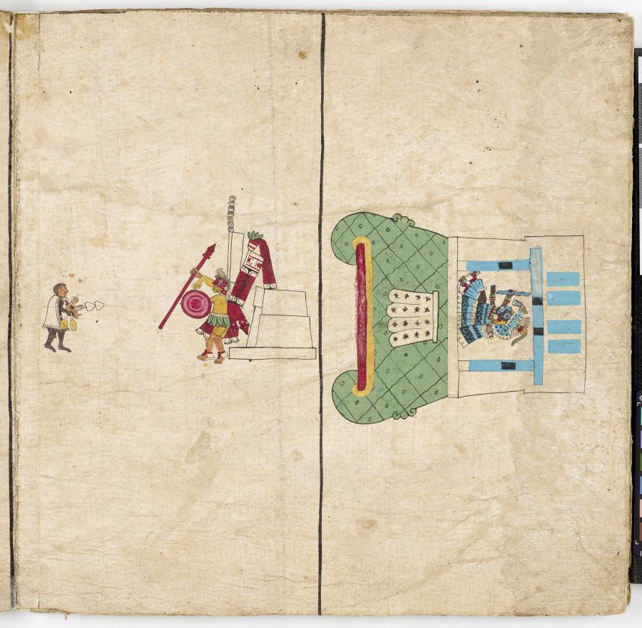
Fig. 4 Nahua artists, Codex Borbonicus, amatl paper, ca. 1525 CE, 40 x 40 cm. Paris, Bibliothèque de l’Assemblée nationale (France), Ms. 1515, f. 24. Source: Bibliothèque de l’Assemblee nationale (France).
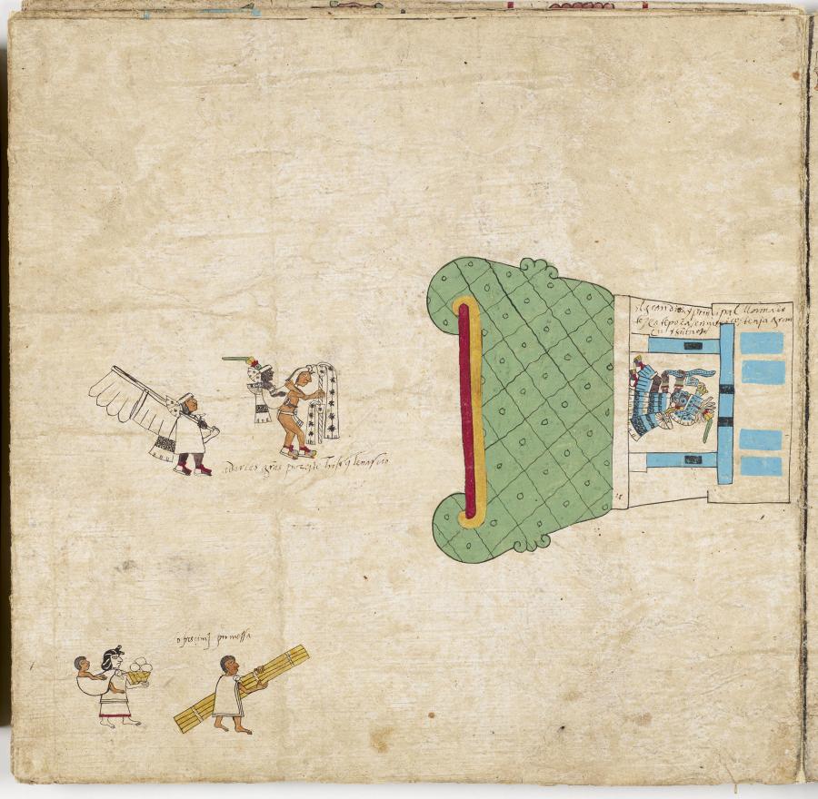
Fig. 5 Nahua artists, Codex Borbonicus, amatl paper, ca. 1525 CE, 40 x 40 cm. Paris, Bibliothèque de l’Assemblée nationale (France), Ms. 1515, f. 25. Source: Bibliothèque de l’Assemblee nationale (France).
The very moment in which the tlahtoque reached the base of Mount Tlaloc is depicted in the Codex Borbonicus. Two illustrations from this sixteenth-century regional manuscript recalibrate the spatial focus of the pilgrimage by shifting attention to the mountain’s slope. The codex’s chapter describing the festivals of the Nahua twenty-day “veintenas,” or months, illustrates the Huey Tozoztli ceremony.1 Following the Indigenous cartographic convention of depicting multiple perspectives and views, pages 24 and 25 illustrate pilgrimages to and up Mount Tlaloc (Figs. 4 and 5).2 In both, and in other renderings of the mountain in the codex’s later illustrations, Mount Tlaloc is illustrated with a level summit, in washes of green, topped with a temple shrine housing its patron deity wielding a lightning bolt. The individual depicted is clearly identified as Tlaloc, as the deity is shown with his characteristic goggle eyes and fanged teeth. The spatial organization of the page encapsulates numerous moments in one. Without the viewer reorienting or moving the pages, the ritual specialists and attendants of the tlahtoque are depicted as processing horizontally across the plate. Page 24 depicts a child being presented to a ritual specialist, to be transported up the mountain as an offering to Tlaloc, while page 25 depicts the moment before the procession to the mountain’s summit, right as the human actors reach the mountain’s base. Baskets of food and ritual paraphernalia are depicted, indicating the ceremonies that would soon take place to inaugurate the rainy season. Mount Tlaloc is depicted on its side at a ninety-degree angle, but when the viewer rotates the plate ninety degrees, the figures are oriented as if ascending the mountain slope towards the summit shrine.
- 1Intriguingly, most recorded festivals during the month of Huey Tozoztli are dedicated to the veneration of Chicomecoatl, the female deity of maize and sustenance, and are not mountain-centric ceremonies. It is possible, then, that the ceremonies on Mount Tlaloc are not the principal festival of Huey Tozoztli but a concurrent ritual act. Catherine R. DiCesare, “Tlaloc Rites and the Huey Tozotli Festival in the Mexican Codex Borbonicus,” Ethnohistory 62, no. 4 (2015): 693, 697.
- 2Josefrayn Sánchez-Perry first pointed out to me that whoever glossed the Codex Borbonicus with alphabetic text labels the figure on page 25 as “el gran díos y principal llamado tezcatepoca” (the great and principal god named Tezcatepoca). While Tezcatlipoca (modern orthography) was a prominent deity in the region, the individual depicted is surely Tlaloc based on his trademark attributes. Even though Tlaloc was known to inhabit numerous mountains in the region, plates 24 and 25 clearly depict the Huey Tozoztli ceremony to Mount Tlaloc, as corroborated by Durán. Josefrayn Sánchez-Perry, personal communication to author, 2021.
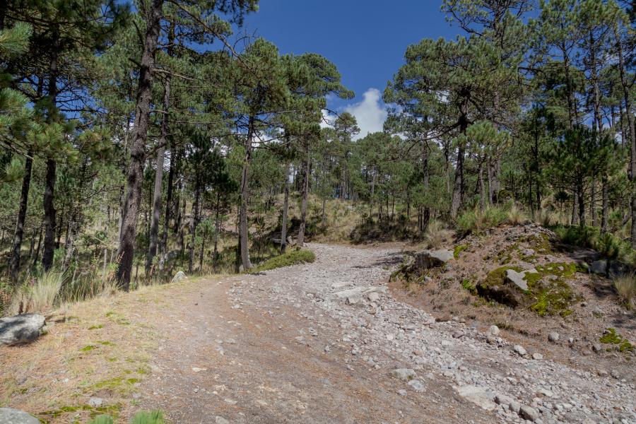
Fig. 6 Pine Forest and Upper Trail of Mount Tlaloc, Mexico. Photograph © Nailotl Mendez. Image source: dreamstime.com, 198176207.
As illustrated in the Codex Borbonicus, the tlahtoque then commenced their climb of Mount Tlaloc (Fig. 6). This specific act of walking upwards and ascending a trail is identifiable in Nahuatl texts. Book 11 of the Historia general de las cosas de la Nueva España, more popularly known as the Florentine Codex, captures individual experience and the components of physical movement as dictated by different types of trails and paths. Written between 1575 and 1577 by Franciscan friar Bernardino de Sahagún alongside a cohort of native Nahuatl speakers, including Antonio Valeriano, Alonso Vegerano, Martín Jacobita, and Pedro de San Buenaventura, the codex is an important source for understanding Nahua culture.1 In Book 11, the definition for trail, or pitzactli, reveals the strenuous nature of walking upwards. The latter part of the definition translates as “it is ascending it is ascending in different places; it is ever meandering; it is choked with weeds, choked with trees, full of rocks.”2 As defined by Karttunen, the word pitzactli is derived from the adjective pitzāhuac, meaning “something thin, slender.”3 Kartunnen elaborates with an example, providing the context: “the road, the thin and subtle wind.”4 Pitzāhuac and its derivative pitzactli invoke the overgrown and uncultivated characterization of ascending mountain trails.
Surrounding the tlahtoque as they ascended the slope of Mount Tlaloc were unique ecological characteristics. In Nahua natural history and worldview, the mountain slope was a distinct geological domain: the upper slope contained its own soil chemistry and a discrete type of agricultural production. Book 11 of Florentine Codex, classifies more many varieties of soil that characterize the upper layer of the earth. In outlining the extensive and taxonomic Nahuatl nomenclature for describing the earth, the content of Book 11 meticulously distinguishes between color, fertility, location, moisture retention, and texture.
Relevant within the context of mountain ecology writ large is the Nahuatl word tetlalli, a soil type found on mountains. Tetlalli describes the overall physical and visual properties of mountain terrain. Tetlalli encompasses dualities; the codex indicates that tetlalli ground can be rough but also agriculturally productive. The Florentine Codex states:
It is land on the mountain—rocky, gravelly, loose-graveled. It is very rocky, gravelly, rough, dry, dry deep down; a productive place, the growing place of tecintli maize. It is dry deep down; it is dry. It hardens; it becomes wet; it produces.5
Corresponding to a broader Nahua attitude toward mountains, this definition encompasses the mountain surface as part of a greater agricultural cycle. Ground can be dry and unyielding. However, with the onset of rain, the soil can transform into the ideal surface environment for seeds to germinate. The duality of this description may also indicate a broader attitude toward mountains. Certainly, mountains were aquatic sources. They provided necessary sustenance to the valleys below. The authors of the Florentine Codex write that mountains were filled to the brim with water, comparable to ollas, or ceramic vessels.6 But mountains, especially those that could also be characterized as volcanos, were dangerous and part of the wilderness.7 Mountain soil was so physically and chemically separate from other locations in the valley that it required its own distinction as dictated by Nahua speakers.
- 1Kevin Terraciano, “Introduction” in The Florentine Codex: An Encyclopedia of the Nahua World in Sixteenth-Century Mexico, eds. Jeanette Favrot Peterson and Kevin Terraciano, (Austin: University of Texas Press, 2019), 13.
- 2Sahagún, Florentine Codex, Book 11, Chapter 12, 267. I utilize the translation provided by Arthur J. O Anderson and Charles Dibble. At times, and within the essay’s prose, I opine on the translation and meanings as informed by Nahuatl analytical dictionaries and contemporary grammatical understandings of the language.
- 3Frances Karttunen, An Analytical Dictionary of Nahuatl (Norman: University of Oklahoma Press, 1992), 197.
- 4Ibid.
- 5Sahagún, Florentine Codex, Book 11, Chapter 12, 253.
- 6Ibid., 247.
- 7Mountains also occupied the urban outskirts and represented densely forested space; wilderness abounded within this terrain. Frances Kartunnen translates cuauhtlah as “mountain, wilderness, forest,” combining the landform with its ecological properties and characteristics. Karttunen, An Analytical Dictionary of Nahuatl, 64.
Locating Tlalocan
While in the Codex Borbonicus Mount Tlaloc was rendered in line with the Nahua visual convention of depicting a green mountain glyph, other evidence refers to the botanical qualities of the mountain slope. Scholars have long identified Mount Tlaloc, and the neighboring landscape, as a microcosm of Tlalocan.1 Some analyses have interpreted the actual mountain as a “point of access” to Tlalocan.2 Tlalocan was chiefly accessed through supernatural apertures as the mythical locale was understood to reside within the earth. Scholars have yet to connect the local ecology to Tlalocan, enriching the ethnohistoric record that recounts the pilgrimage undertaken by the tlahtoque to the mountain’s peak. The Florentine Codex offers insight into how Nahuas conceived of Tlalocan. In Book 6, devoted to Rhetoric and Moral Philosophy, the authors write that Tlalocan was an “earthly paradise,” ruled by Tlaloc.3 They explain:
And then those who have been drowned, those struck by lightning: the old men went saying that they who are good of heart are struck by lightning because the Tlaloque desire them; they long for them. They take them there to their home, Tlalocan. They live by the master, Xoxouhqui, he who is provided with rubber, with incense, Tlamacazqui, lord of Tlalocan. For verily in Tlalocan those who enter, those taken, those struck are submerged there. They live in eternal spring; never is there withering; forever there is sprouting, there is verdure; it is eternally green.4
Tlalocan was an un-earthly domain that was forever sprouting. This mythic, misty locale was ruled by Tlaloc and the Tlaloque (not to be confused with tlahtoque). The Tlaloque, named in the above passage as Xoxouhqui and Tlamacazqui, are chief deities associated with Tlalocan and attendants of Tlaloc. While Tlalocan was Tlaloc’s plane of existence, other deities simultaneously and similarly controlled the un-earthly paradise.
In naming human sacrifice and offerings, the description of Tlalocan links itself to known rituals associated with Mount Tlaloc. The ethnohistoric account of sixteenth-century chronicler Juan Bautista Pomar (ca. 1535 – 1601) complements the Florentine Codex’s description. In his recording of the rituals that took place on Mount Tlaloc’s summit, Pomar describes a white human-shaped stone statue of Tlaloc. Carved out of the spherical shape of the figure’s head was a vessel where white, black, red, and yellow kernels of corn were deposited.5 Into this receptacle, white, black, red, and yellow kernels of corn were also deposited.6 Pomar further elaborates on the offering of children to Tlaloc, stating that after their ritual purpose had been served and their sacrifice complete, they were given to the mountain via a natural cavern at the summit.7 This act was viewed as regenerative, as the bodies of the children were transformed into maize kernels, ensuring the fruitful harvest during the next rainy season.8 Here, this exchange consists of ritual offerings for upcoming rain to fertilize the local soils.
Within Nahua worldview, Tlalocan was not only an un-earthly domain but it was also the repository for human offerings. Those who had been killed by lightning were taken “home” to Tlalocan because Tlaloc longed for them to be within his territory.46 In Tlalocan there is only one type of climate: misty and perpetually rainy.9 In this paradise that characterized Tlaloc’s realm the environment was overflowing with abundance. Maize, gourds, squash blossoms, amaranth, tomatoes, and green beans abounded.10 Mount Tlaloc was the ideal, ever-verdant location from which to successfully petition for rain to effect agricultural renewal.
López Austin suggests Tlalocan was “replicated” within the mountain range and that Tlalocan was a distinct sacred geographical zone.11 Additionally, mountains were more than a simple reflection of this perpetually fertile locale. Mount Tlaloc manifested the agricultural and ecological properties of Tlalocan. Properties, or components, of the natural world were integrated into the larger Nahua cosmovision. Otherworldly and un-earthly locales and domains were not cleanly separated from the terrestrial plane of the known earth. Molly Bassett eloquently teases out the nuances of this larger worldview, especially as cosmovision relates to elements of the natural world. In her weaving of the sacred and the quotidian components of Aztec and Nahua life and experience, Bassett concludes that there are few concrete distinctions. She writes that Aztec religion acknowledged many “animate entities” including parts of the natural world.12 This specific cosmovision “wove the this-worldly and the otherworldly into the tangible and observable environment.”13 The Nahua understood the otherworldly and the earthly to be intertwined. For the Postclassic peoples of Central Mexico, there was no physical distinction between supernatural and natural. Rather the lived world was a complex web that seamlessly wove together physical experience and greater divine understandings. In this way, the surface ecology of Mount Tlaloc’s slope experienced by the tlahtoque was of this earthly domain but also encompassed connotations to the otherworldly lush vegetation of Tlalocan, aiding in the tlahtoque’s pilgrimage.
Durán establishes the relationship between trees, Tlaloc, and Tlalocan. The forest that Tlaloc ruled over could be replicated in urban spaces, acting as a manifestation of Tlalocan.14 While the fir forest that characterizes the mountain’s mid-slope was an ecological indication that the tlahtoque had reached a certain altitude, and completed a certain leg of their pilgrimage, it was also a tree species that was ritually prominent in venerations of Tlaloc. In the Primeros Memoriales, a sixteenth-century Nahuatl text compiled by Sahagún and a Nahua cohort, fir trees and their branches are synonymous with venerations of Tlaloc and the replication of Tlalocan.15
- 1López Austin, Tlalocan y Tamoanchan, 51, 227-228. Osvaldo Roberto Murillo, “Antecedentes históricos y arqueológicos del Monte Tláloc,” in Páginas en la nieve: Estudios sobre la montaña en México, eds. Margarita Loera Chávez y Peniche, Stanislaw Iwaniszewski, and Ricardo Cabrera (Mexico City: INAH-ENAH/CNCA, 2007), 60, 62, 69, 72.
- 2Phillip P. Arnold, Eating Landscape: Aztec and European Occupation of Tlalocan (Niwot: University Press of Colorado, 1999), 87.
- 3Sahagún, Florentine Codex, Book 6, Chapter 8, 35.
- 4Ibid., Book 6, Chapter 21, 114.
- 5Juan Bautista Pomar, Relación de Texcoco, in Nueva Colección de Documentos para la Historia de México: Relaciones de Texcoco y de la Nueva España, eds. Joaquín García Icazbalceta and Alonso de Zurita (México, D.C.: Editorial Salvador Chávez Hayhoe, 1941), 14.
- 6Pomar, Relación de Texcoco, 18; Johanna Broda, “Ritos mexicas en los cerros de la cuenca: Los sacrificios de niños,” in La Montaña en el Paisaje Ritual, ed. Johanna Broda, Stainsław Iwaniszewski, and Ismael Arturo Montero García (México: Conaculta e INAH, 2001), 299.
- 7Ibid., 18; Johanna Broda, “Ritos mexicas en los cerros de la cuenca: Los sacrificios de niños,” in La Montaña en el Paisaje Ritual, ed. Johanna Broda, Stainsław Iwaniszewski, and Ismael Arturo Montero García (México: Conaculta e INAH, 2001), 299; also discussed in Joyce Marcus, “Rethinking Ritual,” in The Archaeology of Ritual, ed. Evangelos Kyriakidis (Los Angeles: Costen Institute of Archaeology, University of California, 2007), 52-53.
- 8Broda, “Ritos mexicas en los cerros de la cuenca,” 299.
- 46Sahagún, Florentine Codex, Book 6, Chapter 8, 35.
- 9López Austin, Tlalocan y Tamoanchan, 216.
- 10Sahagún, Florentine Codex, Book 3, Chapter 2 Appendix, 45.
- 11López Austin, Tamoanchan, Tlalocan, 227-228.
- 12Bassett, The Fate of Earthly Things, 196.
- 13Ibid.
- 14While the tlahtoque undertook their pilgrimage to Mount Tlaloc, ritual activity was underway within the ceremonial precinct of Tenochtitlan. In the plaza opposite the shrine to Tlaloc that was part of the twin-temple construction of the Templo Mayor, the Aztec’s main temple, a miniature forest landscape was created within the massive urban center. The plaza was adorned with trees, bushes, and rocks to emulate the surrounding world and connect the ceremonial precinct to the rainmaking rites undertaken by the ruler. In the center a large tree was erected and connected to four smaller trees via ropes. Durán, The Book of the Gods, 163; López Austin, Tamoanchan, Tlalocan, 223.
- 15While this text was recorded and compiled in the sixteenth century, the Song of Tlaloc hosts numerous pre-Hispanic associations.
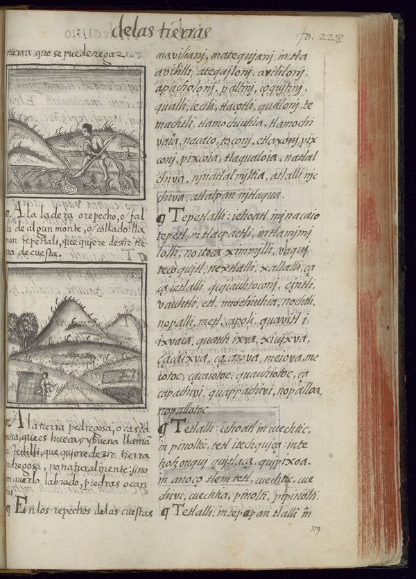
Fig. 7 Bernadino de Sahagún and Nahua artists/scribes, Florentine Codex (detail), 1575-1577 CE, wood-pulp paper and pigment. Florence, Biblioteca Medicea Laurenziana, Ms. Med. Palat. 220, l. 11, f. 228r. With the concession of MiCE. Further reproduction by any means is prohibited.
Importantly, the Florentine Codex also defines tepetlalli, the soil and terrain of a mountain’s upper slope and summit. The characterization of tepetlalli as different from tetlalli indicates that Nahuas conceived of the mountain slope as an ecologically distinct region. The Florentine Codex reads:
This is the top soil of a mountain, the upland, the slope. It is also called ximmilli. It is dry, clayey, ashen, sandy soil, ordinary soil, rain-sown. It is the growing place of mature maize, of amaranth, of beans. It is the sprouting place of the tuna [prickly pear], the nopal, the maguey; of the American cherry; of trees. Trees from shoots, herbs spout, grass sprouts. It becomes grassy; there are maguey plants. The maguey spreads; grass spreads; trees spread. The grasses thicken, trees thicken. The nopal develops; the nopal spreads.1
Frances Karttunen interpreted tepetlalli as unirrigated terrain, literally “hill(side) land.”2 As such, the mountain slope represents a physical space without human intervention (regardless of whether that was the case).3 The taxonomies present in Book 11 of the Florentine Codex speak to a broader relationship between categorizations as based on an individual’s observation and interaction with the soil. The mountain slope was understood as geologically and categorically different than the summit. It had a discernable physical experience, visually and corporeally, for those traversing through the landscape. The Florentine Codex’s illustrations accompanying these classifications, at first glance, indicate human interaction with these surfaces (Fig. 7). Human figures are actively working the land regardless of the codex’s characterization of it as hard, dry, and gravelly. The curving contour of the depicted mountains hosts inky wisps of vegetation on the slopes of the upper piedmont. In the top image laborers work the ground as streams of water swirl beneath the mountain surface, likely indicating the planting of seeds that would lead to a productive rainy season. As the tlahtoque ascended the slope of Mount Tlaloc they did not encounter a generic class of mountain soil. Rather the rulers were confronted with a specific type of soil which was under rain-fed cultivation. The changing soil of Mount Tlaloc’s slope corresponded to the expedition’s tailored goal of inaugurating the rainy season.
As the tlahtoque continued their arduous ascent the surrounding ecology shifted along with the visual and chemical properties of the soil. Geologists divide Mount Tlaloc’s slope into four different ecological zones. Modern scientific surveys note that up to an elevation of 2,949 meters (9,675 feet), the environment is composed of mixed forest which gives way to fir forest.4 At 3,625 meters (11,893 feet), pine forest becomes the dominant vegetation. When reaching 3,815 meters (12,516 feet), pine forest slowly transitions to alpine grassland which then continues and characterizes the open summit of the mountain.5 The soil composition is rich with a “loamy texture.”6 The soil emphasizes the fertile quality of the slope’s landscape, not unlike the Florentine codex’s classification of tepetlalli.7 This specific vegetation distribution is a direct result of the mountain’s elevation as influenced by temperature and annual precipitation.8 This altitudinal gradient and fluctuation of vegetation was a visual as well as sensorial component of the renewal of nature that was sought annually by the tlahtoque. As they continued to ascend Mount Tlaloc’s slope, the changing ecology physically moved them through their pilgrimage.
- 1Sahagún, Florentine Codex, Book 11, Chapter 12, 253.
- 2Karttunen, An Analytical Dictionary of Nahuatl, 230.
- 3Aztec artists intervened in their surrounding environment through Central Mexico, from terracing, to carved boulders, to architectural structures formed in tandem with the living rock. Emily Umberger, “Aztec Art in Provincial Places: Water Concerns, Monumental Sculptures, and Imperial Expansion,” in Altera Roma: Art and Empire from Mérida to Mexico, eds. John D. Pohl and Claire L. Lyons (Los Angeles: UCLA Costen Institute of Archaeology Press, 2016), 109-145.
- 4P. Mayte, S. Jimenez-Noriega, Teresa Terrazas, Laura López-Mata, Arturo Sánchez-González, and Heike Vibrans, “Anatomical Variation of Five Plant Species Along an Elevation Gradient in Mexico City Basin within the Trans-Mexican Volcanic Belt, Mexico,” Journal of Mountain Science 14, no. 11 (2017): 2184-2185, Table 1. Likewise, Townsend notes that fir trees occupied the 11,000-foot altitudinal zone of Mount Tlaloc’s slope. Townsend, “The Mt. Tlaloc Project,” 27.
- 5This scientific survey used the western slope of Mount Tlaloc as their testing site. The western slope of the mountain, the side that faces the valley, was possibly the side that was ascended during pilgrimages. Even if not, the reported ecology is demonstrative of the mountain’s broader vegetation.
- 6Jimenez-Noriega, et al., “Anatomical Variation of Five Plant Species,” 2184.
- 7Ibid., 2184. Although not the focus of this essay, it is certainly worth noting that Mount Tlaloc was also characterized as a stratovolcano. It was non-eruptive during Nahua occupation of the region.
- 8Ibid., 2184-2185.
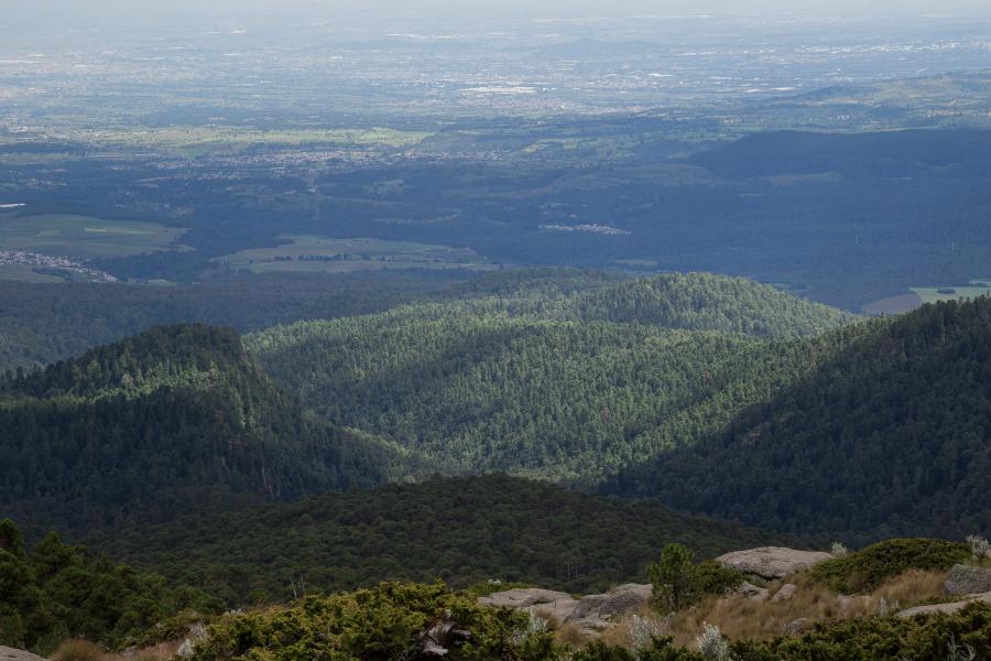
Fig. 9 Expanse of Forested Terrain on Mount Tlaloc’s Slope. Photograph © Nailotl Mendez. Image source: dreamstime.com, 198185257.
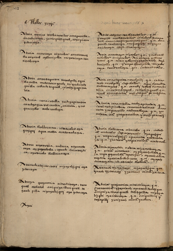
Fig. 8 Bernardino de Sahagún and Nahua scribes, Tlalloc ycuje (“Song of Tlaloc”), Primeros Memoriales, Historia universal de las cosas de la Nueva España, 1558-1585. Patrimonio Nacional. Madrid, Real Biblioteca de Madrid, ii/3280, fol. 274v.
Within the Primeros Memoriales is a ceremonial hymn dedicated to Tlaloc. The fifth stanza of “Tlalloc ycuje”(Song of Tlaloc) (1558-1585) illuminates a local, ecological connection to Tlalocan (Fig. 8). The authors of the “Tlalloc ycuje” provide two columns of text, both in Nahuatl, on a single page. The left column provides the song lyrics; the right column continues the lyrics of the song but adds in commentary on how to construe specific words and lines. While not unknown, this practice is not common when both columns of original text are in Nahuatl.1 The additional commentary provides insight into the words and terms employed in the text. The fifth stanza reads, “Ahuia tlallocan a xivacalco aya / quizqui aqua motta acatonalaya.”2 Thelma D. Sullivan translates this stanza as “From Tlalocan, from the turquoise house / Your forefathers, Acatonal, have come / forth, have seeped forth.”3 The associated commentary in the original Nahuatl reads as “Ahuia tlallocan a xivacalco q.n. in tlalocā / xiuhcalco id est acxoyacalco / aya quizqui. q.n. vmpa valquizq.”4 The commentary from the right column, as translated by Sullivan, explains that Tlalocan manifested as a house of fir, “Ahuia tlallocan a xivacalco means, / Tlalocan, house of turquoise, that is, house of fir. / Aya quizqui means, from there he came forth.”5 The additional commentary provides insight into the words and terms employed in the text. The commentators emphasize Nahua attitudes towards ecology and its relationship to ceremonial practices and the integration and manifestation of otherworldly locales.
Two expressions in the stanza demonstrate a connection to Tlalocan by linking the mythical locale with agricultural lushness and fir trees. “Xiuhcalco,” which translates to “turquoise house,” corroborates the watery and verdant springlike environment of Tlalocan. The other term “acxoyacalco” translates to “house of fir.”6 In specifically naming Tlalocan as the house of fir, the scribes highlight an ecological relationship between Tlalocan and fir trees. The phrase “house of fir,” as identified by Jacques Soustelle in the mid-twentieth century, likely referred to the ritual structures composed of fir or laurel branches that were scattered throughout the landscape.7 The Florentine Codex reports that shrines composed of fir branches were devotional spaces set up along roads or at the center of crossroads.8 These ritual structures and shrines were key components of a Nahua cosmovision that was hinged to meteorological and ecological phenomena. In specifically naming Tlalocan as the house of fir, the scribes designate fir trees as belonging to the botanical makeup of Tlalocan. The branches of the fir trees, which occupied part of Mount Tlaloc’s slope, were utilized in the construction of these ritual houses/shelters throughout the valley. The utilization of fir branches to construct the “house of fir” mentioned in the Tlalloc ycuje indicates that the sacral, ecological components of Mount Tlaloc’s slope were replicated in the many fir houses constructed across the valley. These ritual structures composed of fir branches, at minimum, echo the ecological and ritual associations of Mount Tlaloc’s verdant slope.
- 1In our discussions of this specific text, Josefrayn Sánchez Perry directed my attention to how these two columns of text functioned together. Josegrayn Sánchez Perry, personal communication to the author, 2021.
- 2Bernardino de Sahagún, Los Códices Matritenses, Primeros Memoriales (1558-1585), Real Biblioteca de Madrid, f274v.
- 3Bernardino de Sahagún, Primeros Memoriales, trans. Thelma D. Sullivan (Norman: University of Oklahoma Press, 1997), 133.
- 4Sahagún, Los Códices Matritenses, f274v.
- 5Sahagún, Primeros Memoriales, 133.
- 6Jacques Soustelle, La pensée cosmologique des anciens Mexicains, représentation de monde et de l’espace (Paris: Hermann & Cie, 1940), 48.
- 7Ibid.
- 8Sahagún, Florentine Codex, Book 3, Chapter 2, 12.
The fir trees encountered along Mount Tlaloc’s slope by the tlahtoque were characteristically distinguished within the Central Mexican high-altitude landscape and within Nahua natural history (Fig. 9).1 In Book 11 of the Florentine Codex, the authors classify numerous tree species. Fir trees (oiametl) are “slender, straight” and “like turquoise” while pine trees (ocotl) are “verdant, very verdant” and “a provider of light, a means of seeing, a resinous torch.”2 The caption for the Florentine Codex’s description of fir trees labels the trees as “very precious, very medicinal,” indicating their revered properties in Nahua natural history. Through associations between fir forests and the color turquoise, the authors of the Florentine Codex link the tree species to the deity of rain.
As the nobility ascended the mountain they moved physically and ceremonially through the fir forest to their mountaintop veneration.3 The correlation of Tlalocan and “house[s] of fir” in the Tlalloc ycuje suggests the ruler’s movement up the mountain slope was akin to moving through a region that had ecological associations to Tlalocan. Certainly, and at minimum, the trees were acknowledged for their ceremonial role and the importance of their branches during other rituals. But the physicality of the forest likely figured into the sensorial experience imparted on those moving through the area. Bassett notes that modern speakers of Nahuatl understand plant growth, and physical changes, as a sign of animacy.4 In Mesoamerican visual culture and worldview, the environment was a model with which to clarify and shape the immediate world. The symbolism of the surrounding flora was a profound way in which Nahua peoples experienced and organized the sacred spaces of their world.5 As distilled by López Austin, spaces could manifest as a Tlalocan through ritual activity. In our case, this manifested by the tlahtoque’s peregrination of Mount Tlaloc’s slope.6 Spaces occupied by humans could function as and relate to Tlalocan (the nearby constructed Aztec botanical space of Tetzcotzingo serves as a neighboring example of this earthly manifestation).7 The ecological components of Mount Tlaloc’s slope were simultaneously both real and mythical landscape.
Additionally, the fir trees encountered by the tlahtoque upon the mountain slope created a distinct microclimate. The altitudinal gradient of the mountain’s western slope angles the vegetation away from harsh winds and damaging UV radiation, protecting the trees from the meteorological elements.8 This ecological characterization, among other associations, echoed the eternal verdant lushness associated with Tlalocan. It is possible that the ecology of this specific slope was one of the factors that lead to the mountain’s characterization as Tlaloc’s dwelling place. The botanical weaving of Tlalocan and Mount Tlaloc meant that those ascending the mountain experienced the mythical Tlalocan through an identifiable and proximate space.
- 1Figure 9 (as well as Figure 6) are contemporary photographs of Mount Tlaloc. In utilizing these images to illustrate this essay’s argument, I acknowledge the disjunction between the depicted forested terrain versus ancient forests of the past. The ancient forests of Mount Tlaloc were likely cut down during massive deforestation efforts of the sixteenth century. I use these photographs cautiously balancing them against primary Indigenous sources.
- 2Ibid., Book 11, Chapter 6, 107-108.
- 3As recorded in the early colonial documentary record, fir branches were a component of physical offerings in a Catholic context. Translated by Frances Karttunen, the Nahuatl noun acxoyatl is understood as the fir branches used specifically in penitential offerings. In Book 8 of the Florentine Codex 8, devoted to kings and lords, the authors state “They constrained him to do the penances, setting fir branches [on the city altars] at night, or there where they went to place the fir branches on mountain tops—there were sacrifices were made at midnight.” While this specific ritual does not directly correlate to ceremonies at Mount Tlaloc, the relationship of fir branches to mountaintop ceremonies is of note. Karttunen, An Analytical Dictionary of Nahuatl, 3; Sahagún, Primeros Memoriales, 74, 126; Sahagún, Florentine Codex, Book 8, Chapter 20, 72.
- 4Bassett, The Fate of Earthly Things, 11-14.
- 5Jeanette Favrot Peterson, “Flora and Fauna as Metaphor in Precolumbian Mesoamerica,” in Precolumbian Flora and Fauna: Continuity of Plans and Animal Themes in Mesoamerican Art (San Diego: Mingei International Museum, 1990), 10.
- 6López Austin, Tamoanchan, Tlalocan, 227-228.
- 7Paul Avilés, “Seven Ways of Looking at a Mountain: Tetzcotzingo and the Aztec Garden Tradition,” Landscape Journal 25, no. 2 (2006): 143-157.
- 8Jimenez-Noriega, et al., “Anatomical Variation of Five Plant Species,” 2194, citing Juan A. Encina-Dominquez, Francisco J. Encina-Dominguez, Efrén Mata-Rocha, and Jesús Valdes- Reyna, “Aspectos Estructurales, Composición Florística y Caracterización Ecológica del Bosque de Oyamel de la Sierra de Zapalinamé, Coahuila, México,” Boletín de la Sociedad Botánica de México 83 (2008): 13-24.
Continuing Upwards and Reaching the Summit
Once the tlahtoque moved through the fir tree region of Mount Tlaloc’s slope the foursome next encountered pine trees. Recall that scientific surveys place pine forest at 3,815 meters, after the zone of fir trees. Pine forest, much like fir but a distinct type of tree, had distinct ritual connotations.1 Pine resin certainly had practical uses, it could be made into rubber or chewing gum, but it was also revered as a religious offering and valued for its medicinal use.2 The entry for pine in the Florentine Codex places emphasis on the usage of the wood as a catalyst for vision. It reads, “[t]he pine is embracing. It is a provider of light, a means of seeing, a resinous torch.”3 Pine wood was used for torches and the resin as fuel for the flame, especially during pre-contact ceremonial feasts.4 Durán noted that “even the bark of resinous trees was revered so that it could create a good fire,” indicating that resinous trees, like pine, were crucial to effective ceremonies.5 In conjunction, this upper piedmont area is an ideal habitat for whitetail deer, a common food source in the region.6 Pine forest fostered a “precocious habitat for white-tailed deer” and represented the fertile and life-giving environment that Tlaloc was capable of providing.7 The ecology of the upper slope of Mount Tlaloc right before the timberline is replete with agricultural and ritual significance.
After moving through the pine forest, the tlahtoque’s path to the summit becomes increasingly difficult to navigate as the mountain surface turns jagged due to ancient lava flow.8 Townsend suggests that the tlahtoque climbed the mountain guided by a fifteenth-century aqueduct, after moving through the highly forested area of the mountain’s slope.9 Considering that this aqueduct provided water to the eastern valley of Mexico, Townsend argues that the ritual climb to the summit of Mount Tlaloc ensured essential water was continuously provided to the valley below, thus marking the kings who conducted this ritual as life giving themselves.10
Although Nahua artists rendered the mountains of this region with their icy snow-capped peaks, the physical perception of temperature along Mount Tlaloc’s slope likely differed from our twenty-first century physical understanding.11 Tlalocan, as an eternal springtime and fertile environment, projected warmth, even when meteorological conditions indicated otherwise. Within Nahua worldview, the entirety of the earth’s surface encompassed a radiating, warm energy.12 This energy, or tonalli, is best understood as an animating quality garnered from the sun’s rays.13 Tonalli could also relate to the seasons; its warming quality specifically aligned with the temperate climate of late spring and summer.14 Plants could absorb and capture tonalli.15 Tlalocan was a warm spring where plants possessed the heat-like quality of tonalli.
- 1While fir and pine trees are both classified as conifers and belong to the same plant family, their plant group names are different. Fir trees are categorized as Abies while pine trees are members of the genus Pinus.
- 2James Maffie, Aztec Philosophy: Understanding a World in Motion (Louisville: University Press of Colorado, 2014), 187.
- 3Sahagún, Florentine Codex, Book 11, Chapter 6, 107-108.
- 4Pine torches are illustrated in Primeros Memoriales fol. 252v, Codex Telleriano- Remensis fol. 29r, and the Codex Vaticanus A fol. 84v.
- 5Durán, Ancient Gods and Rites, 290.
- 6William T. Sanders, Jeffrey R. Parsons, and Robert S. Santley, The Basin of Mexico: Ecological Processes in the Evolution of a Civilization (New York: Academic Press, 1979), 88, 282, 476, 479.
- 7Ibid., 479.
- 8Townsend, “The Mt. Tlaloc Project,” 27.
- 9Townsend, “The Renewal of Nature at the Temple of Tlaloc,” 173.
- 10Ibid., 182.
- 11The Codex Nuttall notably features mountains with their snow-capped peaks, including that of Mount Tlaloc. Ferdinand Anders, Maarten Jansen, and Gabina Aurora Pérez Jiménez, El rey 8 Venado, Garra de Jaguar, y la dinastía de Teozacualco-Zaachila: Libro explicativo del llamado Códice Zouche-Nuttall(Madrid: Sociedad Estatal Quinto Centenario, 1992), 114-115.
- 12Maffie, Aztec Philosophy, 271.
- 13Karttunen, An Analytical Dictionary of Nahuatl, 245-246.
- 14Sahagún, Primeros Memoriales, 224, note 13.
- 15Maffie, Aztec Philosophy, 272. Allison Caplan has explored the relationship between tonalli and Nahua featherwork. Allison Caplan, “The Living Feather: Tonalli in Nahua Feather Production,” Ethnohistory 67, no. 3 (2020): 383-406.
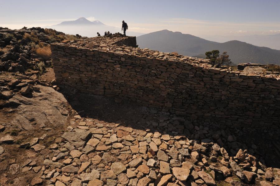
Fig. 10 Walled Enclosure and Vista on the Summit of Mount Tlaloc. Photograph © Kenneth Garrett.
Once at the top the rulers processed around the enclosed courtyard at the summit (Fig. 10).1 Surrounding the effigy of Tlaloc were smaller effigy figures, likely representations of the Tlaloque. Together, the figures replicated the deities of Tlaloc’s domain.2 Townsend describes how, one by one, and in order of rank, the kings presented elaborate gifts—textiles, headdresses composed of fine feathers, jewelry made of precious stones—to Tlaloc and the smaller figures.3 Sumptuous feasts then commenced and the blood of sacrificed children was sprinkled upon the worshipped figures.4 After the offerings on the mountaintop had concluded, the tlahtoque then descended the mountain in celebration.5 In his work on the archaeology of Mount Tlaloc’s summit, Townsend unites Durán’s account with the archaeological record. The summit of Mount Tlaloc was outfitted with a prominent ritual stage; Durán writes of a “large, square courtyard, surrounded by a well-built fence” that was “whitewashed” and “could be seen from many leagues away.”6 This construction in concert with the performed ritual labor created an opening to the “womb of the mountain” below.7 Townsend proposes, in connecting the ethnohistoric accounts to the archaeological record, that the offerings of blood at the mountaintop enclosure were akin to a ritualized fertilization within the womb shape resting on top of the mountain.8 The historic rituals of the mountain summit, as distilled by ethnohistoric and archaeological sources, were made possible only after the tlahtoque physically ascended the mountain slope.
- 1Archaeological evidence corroborates much of Durán’s accounts. However, the material record also illuminates additional aspects of this pilgrimage and ceremony. As suggested by Johanna Broda, the 125-meter processional causeway, attached to the courtyard, was oriented to the east so that those journeying to the shrine were also simultaneously processing towards the sunrise. Anthony F. Aveni, Edward E. Calnek, and Horst Hartung proposed that Tenochtitlan’s Templo Mayor was oriented to align with the eastern summit of Mount Tlaloc. Similarly, Stainsław Iwaniszewski exposed the numerous astronomically aligned sightlines of Mount Tlaloc to the neighboring landforms of Malinche and Pico de Orizaba. Johanna Broda, “Processions and Aztec State Rituals in the Landscape of the Valley of Mexico,” in Processions in the Ancient Americas, ed. Susan Toby Evans (University Park: Penn State University Occasional Papers in Anthropology no. 33, 2016), 189; Anthony F. Aveni, Edward E. Calnek, and Horst Hartung, “Myth, Environment, and the Orientation of the Templo Mayor of Tenochtitlan,” American Antiquity 53 (1988): 287-309; Iwaniszewski, “Archaeology and Archaeoastronomy of Mount Tlaloc, Mexico,” 158-176.
- 2Durán also reported that around the center sculpture of Tlaloc were smaller figures, thought to represent the neighboring mountains. These smaller figures “accompanied Tlaloc, as the other hills accompanied the mountains.” These miniature mountains relate to a similar practice detailed in the Florentine Codex, in which figurines of mountains were molded from amaranth seed dough and represented the landforms of the valley of Mexico, including that of Mount Tlaloc. It is more than likely that the figures represented both adjacent mountains as well as the tlaloque. Durán, Historia de las Indias de Nueva España, 82, my translation.
- 3Durán, The Book of the Gods, 156; Townsend, “The Renewal of Nature at the Temple of Tlaloc,” 176-178.
- 4Durán, The Book of the Gods, 157-58.
- 5Ibid., 160.
- 6Durán, Historia de las Indias de Nueva España, 82, my translation.
- 7Townsend connects this constructed courtyard as an opening to the mountain’s cave/womb relying upon an illustration from the Codex Borbonicus as evidence. In this illustration, the creator gods are sitting within a rectangular enclosure as water flows from the courtyard enclosure’s opening. Townsend, “The Renewal of Nature at the Temple of Tlaloc,” 179.
- 8Ibid., 182.
Conclusion
Within the context of Late Postclassic Central Mexico a ritual of high-altitude pilgrimage was undertaken by four rulers. Not only did this pilgrimage inaugurate the rainy season, it also corresponded to the pan-Mesoamerican concept that pilgrimage and concurrent ritual acts were part of a larger effort to maintain balance and continuity within the world.1 In their trek horizontally across the Basin of Mexico and then vertically up the slope of Mount Tlaloc, the tlahtoque were actively involved in veneration of the rain deity even before reaching the mountain’s summit. A reevaluation of this ritual indicates that the ascension of the mountain slope was itself important for local rulers. The ecological context of Mount Tlaloc’s slope was grafted onto the physical experience of pilgrimage, contributing to an all-encompassing journey of renewal. The mountain slope possessed the physical and ecological capacity to render it as a localized Tlalocan, made manifest by the rulers’ interaction with and understanding of the space as they moved through it. Ascension through this earthly paradise further enhanced the rain renewal ceremonies that would continue on the mountain’s summit. This distinct ecological discourse shifts our perception of the mountain’s overall physical role in rain renewal ceremonies. A consideration of the mountain slope highlights how the totality of its steep sides and exposed bedrock contributed to pilgrimage experiences. Even today, the legacy of Postclassic and Late Postclassic conceptions of Mount Tlaloc resonate as it is still venerated as a sacred location. Numerous pilgrims continue to ascend the slope to worship on its peak.2
- 1For a discussion on pan-Mesoamerican ritual, see Jeremy D. Coltman and John M.D. Pohl, ed., Sorcery in Mesoamerica (Louisville: University Press of Colorado, 2020). For a Maya comparison, see Joel Palka, Maya Pilgrimage to Ritual Landscapes: Insights from Archaeology, History, and Ethnography (Albuquerque: University of New Mexico Press, 2014).
- 2Iwaniszewski, “Archaeology and Archaeoastronomy of Mount Tlaloc, Mexico,” 162. Iwaniszewski writes of a “modern shrine” and “six wooden crosses inserted into a wall,” indicating the presence of modern ceremonies. While Iwaniszewski’s report is from 1994, the mountain peak is still thought of as a revered location in the twenty-first century.
About the Author

Notes
Imprint
Author
Catherine H. Popovici
Year
2022
Type
Essays
Volume
Volume 5: Issue 2 Material Religion of High Altitude Ecologies
Copyright
©
Catherine H. Popovici
Downloads
PDF
DOI
10.22332/mav.ess.2022.7
Citation Guide
1. Catherine H. Popovici, "The Ritual Ascent at Mount Tlaloc, Mexico," Essay, MAVCOR Journal 5, no. 2 (2022), doi: 10.22332/mav.ess.2022.7.
Catherine H. Popovici. "The Ritual Ascent at Mount Tlaloc, Mexico." Essay. MAVCOR Journal 5, no. 2 (2022), doi: 10.22332/mav.ess.2022.7.

